NOTICES
GAME COMMISSION
Chronic Wasting Disease—Designation of Disease Management Areas and Endemic States and Canadian Provinces Order # 13
[53 Pa.B. 3793]
[Saturday, July 15, 2023]
Executive Order Whereas, Chronic Wasting Disease (CWD) is an infectious and progressive neurological disease that is found in, and always proves fatal to, members of the family Cervidae (deer, elk or moose, and other susceptible species, collectively called cervids); and
Whereas, There are no known treatments for CWD infection, no vaccines to protect against CWD infection, and no approved tests that can detect the presence of CWD in live cervids; and
Whereas, CWD is designated as a ''dangerous transmissible disease'' of animals by order of the Secretary of Agriculture under 3 Pa.C.S. § 2321(d) (relating to dangerous transmissible diseases); and
Whereas, The Game and Wildlife Code (Code) (34 Pa.C.S. §§ 101 et seq.) and regulations promulgated thereunder (58 Pa. Code §§ 131.1 et seq.) collectively provide broad authority to the PGC to regulate activities relating to the protection, preservation, and management of game and wildlife, including cervids; and
Whereas, On March 28, 2017 (effective May 16, 2017), the Commission added 58 Pa. Code § 137.35 (relating to Chronic Wasting Disease Restrictions) to give more permanent status and structure to the CWD requirements and restrictions previously established and maintained over the prior decade by and through executive orders; and
Whereas, Section 137.35(d) provides the Executive Director with the authority to designate CWD Disease Management Areas (DMAs) and Established Areas (EAs) within this Commonwealth; and
Whereas, Previous executive orders concerning designation of CWD DMAs and EAs within this Commonwealth were issued by the Commission on June 1, 2017, July 24, 2017, October 6, 2017, February 16, 2018, May 21, 2018, October 22, 2018, June 17, 2019, June 2, 2020, May 28, 2021, October 21, 2021, April 5, 2022, and August 18, 2022; and
Whereas, The Commission has determined that further designations of CWD DMAs and EAs are required to implement necessary updates to the Commission's CWD program.
Now Therefore, I, BRYAN J. BURHANS, Executive Director of the Pennsylvania Game Commission, pursuant to the authority vested in me by the Code and regulations promulgated thereunder, do hereby order and direct the following:
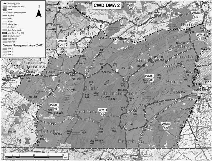
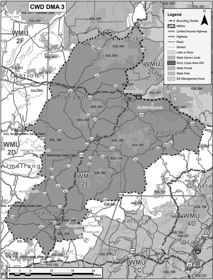
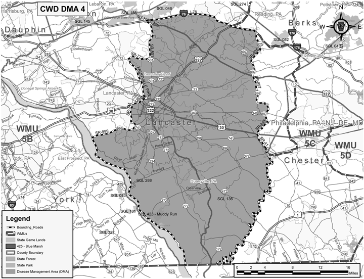
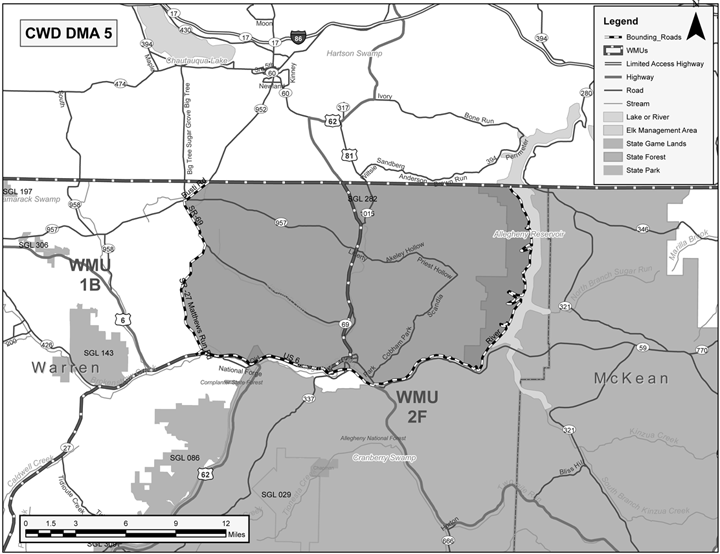
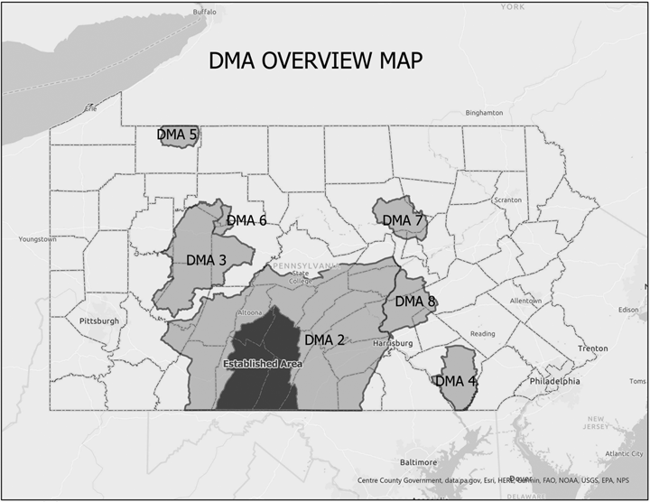
1. DMAs within this Commonwealth are designated as set forth below. These DMAs are more graphically illustrated on the maps titled ''DMA 2,'' ''DMA 3,'' ''DMA 4,'' ''DMA 5,'' ''DMA 6,'' ''DMA 7,'' ''DMA 8'' and ''DMA OVERVIEW'' attached hereto and incorporated by reference herein. Should any conflict exist between the below-listed written boundaries and maps of DMA 2, DMA 3, DMA 4, DMA 5, DMA 6, DMA 7, DMA 8 and DMA OVERVIEW, the written descriptions shall prevail.
a. DMA 1: Eliminated.
b. DMA 2: Adams, Bedford, Blair, Cambria, Centre, Clearfield, Cumberland, Franklin, Fulton, Huntingdon, Indiana, Juniata, Mifflin, Perry, Snyder, Somerset, Union, Westmoreland, and York counties, bounded and described as follows: Beginning at the intersection of Taneytown Road (State Highway 134) and the Maryland State Line, proceed north on State Highway 134 for approximately 4 miles to US Highway 15. Follow US Highway 15 north for 36.4 miles to the intersection where State Route 581 becomes US-11. Continue north on US Highway 11 for 2.4 miles to the point it meets the west shore of the Susquehanna River at Front Street in Wormleysburg. Follow the Susquehanna River north for approximately 62.6 miles to the river bridge (State Highway 45) in Lewisburg. Continue west on State Highway 45 for approximately 45.6 miles to State Highway 144 in Old Fort. Continue south on State Highway 144 for approximately 3.8 miles to US Highway 322 in Potters Mills. Proceed west on US 322 for approximately 17 miles, merging onto Interstate 99 and continuing west along Interstate 99 for approximately 7.2 miles to Exit 62 and returning to US Highway 322. Continue west on US 322 for another 10.9 miles to State Highway 504 in Phillipsburg. Proceed west on State Highway 504 and follow 0.6 miles to State Highway 53. Continue west on State Highway 53 for 9.5 miles to State Route 153 in Houtzdale. Proceed south on State Route 153 for 5.9 miles to State Highway 253 (Viola Pike). Follow State Highway 253 south for 8.6 miles to State Highway 53 in Van Ormer. Continue south on State Highway 53 for 1.7 miles to Marina Road. Continue west on Marina Road for 5.5 miles where the road becomes Glendale Lake Road. Continue west on Glendale Lake Road for 3 miles State Highway 36. Follow State Highway 36 west for .5 miles into the town of Patton. Continue north on State Highway 36 for 3.5 miles to Bridge Street. Continue west on Bridge Street for 1.6 miles to Spangler Street. Follow Spangler Street south for .9 miles to Municipal Road (SR 4016). Proceed north on Municipal Road for 3.6 miles west to US Highway 219 (Crawford Avenue) in Northern Cambria. Follow US Highway 219 south for 1.3 miles to State Highway 271. Follow State Highway 271 south for 2.8 miles to State Highway 553 near Nicktown. Follow State Highway 553 west for 6.9 miles to State Highway 403 near Heilwood. Continue south on State Highway 403 for 15.8 miles to US Highway 22. Follow US Highway 22 west for 14 miles to State Highway 217 South in Blairsville. Continue south on State Highway 217 for 12.5 miles to US Highway 30. Follow US Highway 30 east for 21.3 miles to US Highway 219. Proceed south along State Highway 219 for 32.6 miles to the Maryland border. Finally, continue east along the Maryland border 100.05 miles to Taneytown Road (State Highway 134) at the place of beginning.
c. DMA3: Armstrong, Cambria, Clarion, Clearfield, Elk, Indiana, and Jefferson counties, bounded and described as follows: Beginning at the intersection of Campbells Mill Road and US Highway 119 in the town of Black Lick, proceed north on US Highway 119 for 5.3 miles to State Highway 56. Follow State Highway 56 east for 5.5 miles to State Highway 259. Continue north on State Highway 259 for 5.4 miles to US Highway 422. Follow US Highway 422 west for 3.4 miles to State Highway 553. Follow State Highway 553 east for 1.9 miles to Spaulding Road. Continue north on Spaulding Road for 3 miles to State Highway 403. Follow State Highway 403 north for 2.2 miles to State Highway 286. Continue east on State Highway 286 for 4.9 miles to State Highway 240. Follow State Highway 240 east for 8.5 miles to US Highway 219. Follow US Highway 219 north for 2.4 miles to Sylvis Road. Follow Sylvis Road east for 5.8 miles to State Highway 36. Follow State Highway 36 east for 8.8 miles to La Jose Road (SR-3016) in Newburg. Follow La Jose Road east for 3.6 miles becoming Cherry Corner Road (SR-3005) for another .3 mile to Marron Road (SR-3016). Proceed northeast on Marron Road for 2.7 miles to State Road 729. Follow State Road 729 north for .9 miles to Old Station Road. Follow Old Station Road (SR-2012) east for 2.4 miles to Douglas Road (SR-3007). Continue east on Douglas Road for .3 miles to Zion Road (SR-2012) near New Millport. Follow Zion Road east for 4.5 miles to Faunce Road (SR-2012). Follow Faunce Road east for 3.1 miles becoming Sanborn Road (SR-2012). Continue east on Sanborn Road for 2.5 miles to State Highway 153. Follow State Highway 153 north for 5 miles to Valley Road (SR-2027). Follow Valley Road north for 2.1 miles becoming Hogback Hill Road (SR-2027). Continue north on Hogback Hill Road for 1 mile to Main Street in Mineral Springs. Continue east on Main Street for .2 miles to Bigler Cutoff Road. Follow Bigler Cutoff Road north for .1 miles to US Highway 322. Proceed east on US Highway 322 for .7 miles to State Highway 970. Follow State Highway 970 north for 1.5 miles to Interstate Highway 80. Follow I-80 west for 26.4 miles to State Highway 219. Follow State Highway 219 north for 21.2 miles to Boot Jack becoming State Route 948. Follow State Route 948 for 4.2 miles to the Clarion River in Ridgway. Follow the Clarion River west for 28.3 miles to Bridge Road. Continue south on Bridge Road for 0.05 mile to State Highway 949. Proceed west on State Highway 949 for 16.3 miles to US Highway 322 in Corsica. Follow US Highway 322 east for 0.3 miles to State Highway 949. Follow State Highway 949 south for 4.2 miles to State Highway 28. Follow State Highway 28 south for 13.2 miles to State Highway 839 in New Bethlehem. Follow State Highway 839 south for 21 miles to State Highway 85. Follow State Highway 85 south for 3.9 miles to State Highway 210. Continue south on State Highway 210 for 10.5 miles. Proceed north on US Highway 422 for 0.5 mile to Girty Road. Follow Girty Road west for 7.3 miles to State Highway 156. Follow State Highway 156 south for 2 miles to West Lebanon Road. Continue east on West Lebanon Road for 0.3 mile to Olivet Road. Continue south on Olivet Road for 3.1 miles which becomes Iselin Road. Continue south on Iselin Road for 3.3 miles to State Highway 286. Follow State Highway 286 east for 6.5 miles to State Highway 217. State Highway 217 south for 1.4 miles to Black Lick Road. Follow Black Lick Road southeast for 6 miles to Campbells Mill Road. Continue east on Campbells Mill Road 0.4 mile to US Highway119 at the place of beginning.
d. DMA 4: Lancaster County, bounded and described as follows: Beginning in the city of Litiz, at the intersection of state Route 772 and State Route 501, proceed north on State Route 501 for 5.1 miles to US Route 322. Proceed west on US Route 322 for 1.2 miles to Interstate 76 (Pennsylvania Turnpike). Continue east on Interstate 76 (Pennsylvania Turnpike) for 16.9 miles to State Route 625 (Reading Road). Follow State Route 625 (Reading Road) south for 6.4 miles to State Route 23. Continue west on State Route 23 for 0.3 miles to State Route 897. Follow State Route 897 south for 0.6 miles to U.S. Route 322 (28th Division Highway). Follow U.S. Route 322 (28th Division Highway) east for 0.1 miles to State Route 897 (Spring Valley Road). Follow State Route 897 south for 4.2 miles to Seldomridge Road (T-513). Continue east on Seldomridge Road (T-513) for 1.8 miles to Cambridge Road (T-907). Follow Cambridge Road south for 1.6 miles to State Route 340 (Old Philadelphia Pike). Continue west on State Route 340 (Old Philadelphia Pike) for 0.4 miles to State Route 897 (White Horse Road). Continue south on State Route 897 for 4.0 miles to U.S. Route 30. Follow U.S. Route 30 west for 0.3 miles to State Route 41 (Newport Pike). Continue south on State Route 41 for 3.0 miles to Pine Creek. Follow Pine Creek south for 0.9 miles to East Branch Octoraro Creek. Continue south on East Branch Octoraro Creek for 18.2 miles to Octoraro Creek. Follow Octoraro Creek south along the Chester/Lancaster County border for 13.1 miles to the intersection with the Maryland border. Continue west along the Maryland border for 4.7 miles to the shoreline of the Susquehanna River. Proceed north along the Susquehanna River shorelines for 26.0 miles to a point abeam State Route 999. Continue east on State Route 999 for 7.0 miles to State Route 741 (Rohrerstown Road). Follow State Route 741 (Rohrerstown Road) north for 3.6 miles to U.S. Route 30 (Lincoln Highway). Continue east on U.S. Route 30 for 2.4 miles to State Route 4011 (Fruitville Pike). Follow State Route 4011 (Fruitville Pike) north for 6.7 miles to State Route 772 (Orange Street). Continue east on State Route 772 east for 3.6 miles to State Route 501 at the place of beginning.
e. DMA 5: Warren County, bounded and described as follows: Beginning at the intersection of the Allegheny River and the New York State Line, proceed south on the west shore of the river for 27.8 miles to the bridge at Pennsylvania Ave East (Business U.S. Route 6) in Warren. Continue south on Pennsylvania Ave East (Business U.S. Route 6) for 0.1 mile to U.S. Route 6. Follow U.S. Route 6 west for 11.6 miles to West Main St (State Route 27) in Youngsville. Continue northeast on West Main St (State Route 27) for 0.5 mile to State Route 27 (Matthews Run Road). Follow State Route 27 (Matthews Run Road) north for 7.2 miles to State Route 69 (Jackson Run Road). Continue north on State Route 69 (Jackson Run Road) for 3 miles to State Route 957 (Main St) in Sugar Grove. Follow State Route 957 east for 0.2 miles to Jamestown Street. Continue north on Jamestown Street for 0.7 miles to where Jamestown Street becomes Busti Road. Continue north on Busti Road for 1 mile to the New York border. Finally, follow the New York border east for 18.1 miles to the Allegheny River at the place of beginning.
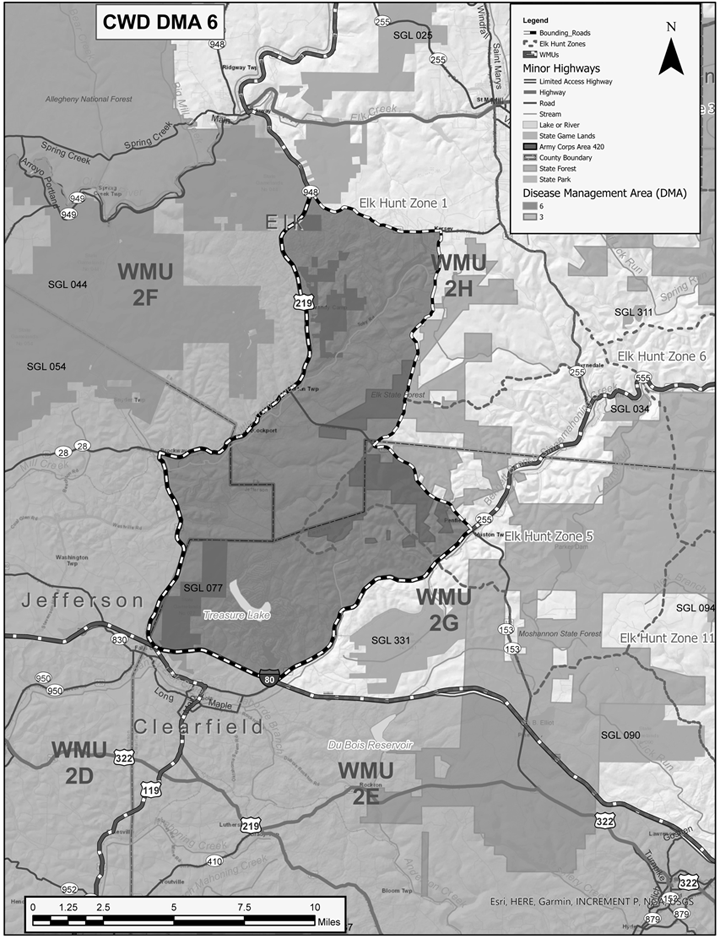
f. DMA 6: Clearfield, Elk, and Jefferson Counties, bounded and described as follows: Beginning in the town of Kersey at the intersection of Chicken Hill Road and State Route 948, proceed south on Chicken Hill Road for 0.9 mile where the road becomes South Kersey Road. Follow South Kersey Road south for 1.4 miles where the road becomes Boone Mountain Road. Continue south on Boone Mountain Road for 6.5 miles to State Route 153. Follow State Route 153 south for 4.9 miles to State Route 255. Follow State Route 255 south for 9.5 miles to Interstate Highway 80. Follow Interstate Highway 80 west for 4.4 miles to State Highway 219. Continue north on State Highway 219 for 21.1 miles to State Route 948. Follow State Route 948 east for 5.3 miles to Chicken Hill Road in Kersey at the place of beginning.
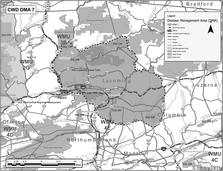
g. DMA 7: Columbia, Lycoming, Montour, Northumberland, and Sullivan Counties, bounded and described as follows: Beginning in the town of Trout Run at the intersection of State Route 15 and State Route 14, proceed north on State Route 14 for 4.5 miles to Field Station Road. Continue southeast on Field Station Road for 2.3 miles to Beech Valley Road. Follow Beech Valley Road southeast for 0.9 mile to Calvert Road. Follow Calvert Road south for 0.1 mile to Southard Road. Continue east on Southard Road for 2.5 miles to Wallis Run Road. Follow Wallis Run Road east for 7.6 miles to Hoppestown Road in the town of Proctor. Continue northeast on Hoppestown Road for 5.9 miles to State Route 87 at Hillsgrove. Follow State Route 87 south for 2.4 miles to Ogdonia Road in the town of Ogdonia. Continue south on Ogdonia Road for 3.0 miles Loyalsock Trail Road. Continue south on Loyalsock Trail Road, becoming Route 3005, then State Route 2083, and then Deer Lake Road for 6.6 miles to State Route 220. Continue east on State Route 220 for 5.6 miles to State Route 42 in Beech Glen. Follow State Route 42 south for 17.1 miles to State Route 254 in Millville. Continue southwest on State Route 254 for 3.5 miles to State Route 44 in Jerseytown. Follow State Route 44 west for 10.8 miles to State Route 54 in Turbotville. Continue northwest on State Route 54 for 10.9 miles to State Route 15. Follow State Route 15 northwest for 6.5 miles to Interstate 180 in Williamsport. Continue west on Interstate 180 for 2.0 miles returning to State Route 15 at Exit 29. Continuing north on State Route 15 for 12.7 miles to State Route 14 in Trout Run at the place of beginning.
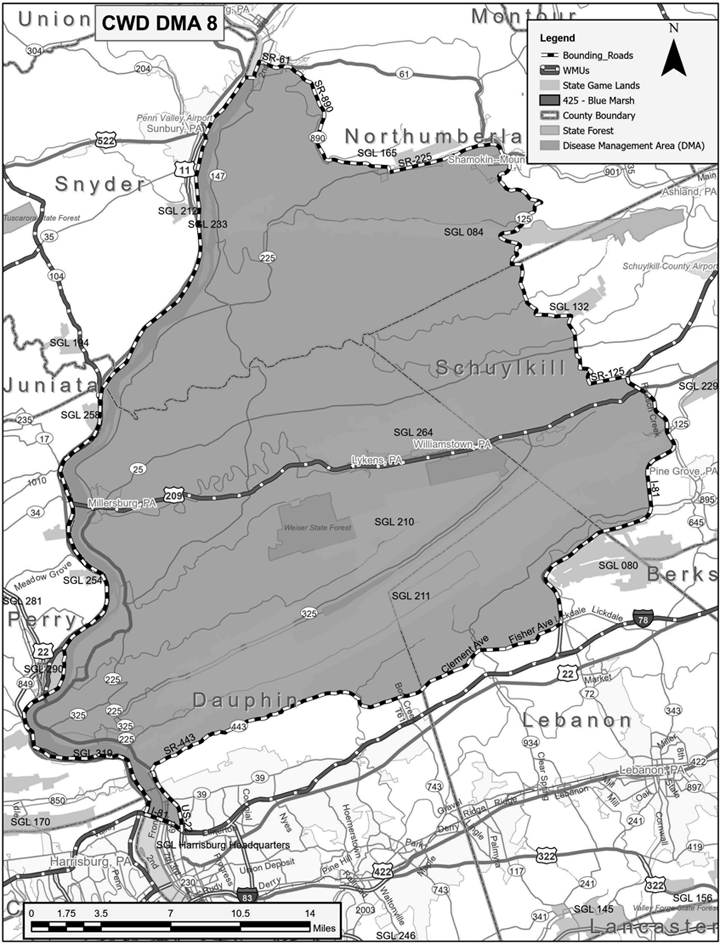
h. DMA 8: Dauphin, Lebanon, Northumberland, and Schuylkill Counties, bounded and described as follows: Beginning at the intersection of Interstate 81 and US Highway 22, proceed west on Interstate 81 for 2.1 miles to the west shore of the Susquehanna River. Follow the west shore of the Susquehanna River north for 48.8 miles to State Route 147 in Shamokin Dam. Continue east on State Route 147 for 0.47 mile to State Route 61. Follow State Route 61 east for 2.6 miles to State Route 890. Continue southeast on State Route 890 for 9.0 miles to State Route 225. Continue east on State Route 225 for 6.2 miles to State Route 61. Follow State Route 61 southeast for 0.3 mile to State Route 125. Continue south on State Route 125 for 21 miles to Interstate 81. Follow Interstate 81 south for 17.5 miles to Fisher Avenue at exit 90 near Bordnersville. Continue west on Fisher Avenue for 3.1 miles to Clement Avenue. Follow Clement Avenue west for 2.4 miles where Clement Avenue becomes State Route 443. Continue west on State Route 443 for 17.7 miles to US Highway 22. Follow US Highway 22 south for 3.6 miles to Interstate 81 at the place of beginning.
2. Established areas within this Commonwealth are designated as set forth below. The sole EA is more graphically illustrated on the map titled ''DMA 2'' attached hereto and incorporated by reference herein. Should any conflict exist between the below-listed written boundary and map of ''DMA 2'', the written descriptions shall prevail.
a. Established Area in DMA 2: Bedford, Blair, Franklin, Fulton, and Huntingdon counties, bounded and described as follows: Beginning at the intersection of State Highway 75 (Fort Loudon Road) and the Maryland State Line near Kasiesville, proceed north on State Highway 75 (Fort Loudon Road) for 13.9 miles to US Highway 30. Follow US Highway 30 west for 7.8 miles to US Highway 522 just north of McConnellsburg. Continue north on US Highway 522 for 37.5 miles to US Highway 22. Follow US 22 west for 42.4 miles to Old Route 22 in Duncansville. Continue west on Old Route 22 for 2.0 miles to Valley Forge Road. Follow Valley Forge Road south for 3.4 miles to the Poplar Run Road. Continue southeast on Poplar Run Road for 0.5 mile to Knob Run Road. Follow Knob Run Road southwest for 4.3 miles where the road becomes Knob Road. Continue south on Knob Road for 3.4 miles to the Bedford/Blair County Line, where the road becomes Blue Knob Road. Follow Blue Knob Road south for approximately 1.0 mile to State Forrest Road in Blue Knob State Park. Follow State Forrest Road south for 3.5 miles where the road becomes Pavia Road. Continue south on Pavia Road for 0.25 miles to State Highway 869. Follow State Highway 869 south for 3.4 miles to State Highway 96. Continue south on State Highway 96 south for 14.4 miles to US Highway 30 in Schellsburg. Follow US Highway 30 east 4.75 miles to State Highway 31. Follow State Highway 31 southwest for 3.4 miles to State Highway 96 in Manns Choice. Continue south on State Highway 96 for 22.25 miles to the Maryland border. Finally, follow along Maryland border east for 47.1 miles to State Route 75 at place of beginning.
3. The previous executive order concerning designation of CWD DMAs and CWD-endemic States and Canadian Provinces within this Commonwealth that was issued by the Commission on August 18, 2022, and published in the Pennsylvania Bulletin on September 3, 2022, at 52 Pa.B. 5747, is hereby rescinded in its entirety and replaced by this Order.
4. This Order is effective immediately and shall remain in effect until rescinded or modified by subsequent order.
Given under my hand and seal of the Pennsylvania Game Commission on this 22nd day of June, 2023.
BRYAN J. BURHANS,
Executive Director
[Pa.B. Doc. No. 23-950. Filed for public inspection July 14, 2023, 9:00 a.m.]
No part of the information on this site may be reproduced for profit or sold for profit.This material has been drawn directly from the official Pennsylvania Bulletin full text database. Due to the limitations of HTML or differences in display capabilities of different browsers, this version may differ slightly from the official printed version.