
[39 Pa.B. 1683]
[Saturday, April 4, 2009]
[Continued from previous Web Page]
APPENDIX B
Commonwealth of Pennsylvania Fish Community Sampling Protocol
June 29, 2006 (Revised March 2009)The Department of Environmental Protection shall require Pre Dredging Fish Sampling for the 2006 permit cycle. This sampling, protocol and criteria shall be used to satisfy the requirements of the Pennsylvania National Diversity Index process (''PNDI'') search, survey and conflict resolution. The sampling study parameters, protocol and criteria are as follows:
PRE DREDGING The industry shall conduct benthic trawling sampling of fish in areas proposed for dredging according to this Department protocol. Four (2 minute) unsnagged benthic trawls per segment (including buffer segments) are required. All sampling detailed below must occur between May 1 and October 1. Outside of that 5-month sampling window, surveys must be conducted with a temperature criterion of greater than or equal to 10° C (50° F) which has been achieved for a minimum of 5- consecutive days prior to the survey and must be maintained during the survey. The temperature can be monitored at the following USGS web site:
* For the Allegheny River: http://waterdata.usgs.gov/nwis/uv?cb_00010=on&cb_00400=on&cb_00095=on&cb_ 00300=on&format=gif_default&period=7&site_no=030 49640.
* For the Ohio River: http://waterdata.usgs.gov/nwis/uv?03085734
Presently there exists only one temperature gauge on the Allegheny River and one on the Ohio River in PA. If in the future, additional gauges are added to the rivers then the closest gauge to the sampling site should be used for monitoring temperatures.
Notice must be provided to the Department a minimum of 7 days prior to initiation of a fish survey.
Sampling Methods and Procedures
Gear Type
Benthic Trawl
The trawl to be utilized is an extremely effective gear for sampling benthic lithophils (Herzog et al. 2005). The effectiveness of the benthic trawl shall vary based on the bottom substrate, river bed obstructions, boat speed (this shall determine the opening size of the net) and reaction of the fish. In the event that the trawl becomes snagged or turns over, this shall constitute a failed sampling event. The operators must retrieve the trawl, discard the contents of the failed trawl and reset the trawl for a new sampling event.
The Missouri-type 8 ft. wide trawl design described by Herzog et al. (2005) shall be the standard trawl employed during these surveys. The trawl's cod end is manufactured of 2.14 meters (7.02 ft) long 1.5 mm (1/17 in) diameter nylon twine with 19.05 mm (3/4 in) bar mesh and is lined with 3.18 mm (1/8 in) ace-style mesh. The body is manufactured with No. 7 (1-3/8 in. sq. mesh) netting and the bag is manufactured with No. 12 (1-1/4 in. sq. mesh) netting. The two trawl boards are 40.64 cm (16 in.) by 34.13 cm (9.5 in.) and equipped with 1.59 cm (5/8 in.) diameter twisted nylon tow lines 30.48 m (100 ft) in length. The footrope is 1.59 cm in diameter and 5.48 m (17.9 ft) long. The trawl chain is 44 mm (1 3/4") L by 25.4 mm (1") H by 6.4mm (1/4") diameter. Ideally, the trawl shall be fished from a Jon boat 5.49-6.4 m (18-21 ft in length). The trawl shall be attached to two hard points on the boat with 9.5 mm (3/8 in) braided nylon rope. To effectively fish the trawl, ropes of various lengths should be used, depending on water depth. In water depths of 5 m (16.4 ft) or less, 15.24 m (50 ft) towlines should be used and at water depths between 5 m (16.4 ft) and 10 m (32.8 ft) towlines 30.48 m (100 feet) in length should be used. The length of rope utilized should be recorded on the data sheets provided in addition to river depth at the time of sampling. A small float should be attached to the end of the codpiece with a braided nylon rope. The rope should be longer than the maximum depth to be sampled. In the event the trawl has to be disconnected from the boat, the float shall mark the location of the trawl, facilitating recovery. The trawl shall be towed for 2-minutes unsnagged moving backwards downstream just faster than the current.
General Sampling Design
Using a depth finder or other appropriate gear type, the 6-foot depth contour shall be located at a minimum of three contiguous points along the proposed standard 0.1-mi linear sampling zone. Perpendicular to these points, the 150-foot no dredge area (buffer) shall be determined using an appropriate method (that is, laser range finder). This distance shall be marked with additional buoys to demark the edge of the buffer zone and the beginning of the dredge zone. The location of each sampling event shall be indexed by river mile and marked with a global positioning system device.
Any permit request shall include a one-segment upriver and a one segment downriver station which must also be sampled. For example, if (5)-0.1 mile segments are requested then (7)-0.1 mile segments need to be sampled. All benthic trawling events must be completed within the time window between 2 hours after sunrise and 2 hours before sunset. Benthic trawl sampling shall occur within each 0.1 mi. reach as follows: three benthic trawls shall be performed within the proposed dredge zone and one benthic trawl shall be performed within the 45.72 m (150 ft) buffer. In addition, one benthic trawl shall be performed 0.1-mi upriver and 0.1-mi downriver from the proposed dredge zone (Figure 2). These 2 additional up- and downriver trawls shall be performed within the buffer area (2 trawls total) and in the adjacent up- and downriver dredge zones (6 trawls total). Therefore, a minimum total of 12 trawls shall be required to cover the 0.3-river mile sampling area. Data shall be recorded and reported for each individual trawl sample.
Criteria
If the benthic lithophils identified in Table 2 are collected during the surveys several outcomes are possible. If any Category 1 fishes are collected during benthic trawling sampling events, the permit area shall be restricted from dredging and a 0.3-mile upriver and 0.1-mile downriver no-dredge buffer shall be established; If any Category 2 species are collected during Phase I benthic trawling, then Phase 2 sampling shall be completed within 30 days (see Phase II sampling protocol). If three or more Category 3 species are collected during Phase I benthic trawling, then Phase II sampling shall be completed within 30 days (see Phase II sampling protocol). If no Category 1, 2 or 3 species are collected during Phase 1 trawl sampling events dredging for that river segment shall be authorized.
Phase II
If fish species listed in Category 2 (Table 2) are collected during Phase I sampling, then additional sampling under Phase II shall be required. Phase II sampling shall consist of benthic trawl sampling only, 0.30-mi upriver and 0.20-mi downriver from the proposed dredged area (Figure 3). If permittees do not seek authorization to dredge on the opposite side of the river then that area may be sampled with benthic trawling in Phase II. The additional sampling shall occur in 0.1-mi increments and shall consist of a maximum of three trawls for each 0.1-mi increment. Data shall be recorded and reported for each individual trawl sample. Hence, the standard sampling unit is three benthic trawls for Phases I and II sampling. During Phase II sampling, a minimum of five trawls is required. If any Category 2 fishes are collected, the same species of Category 2 fish shall be documented within a 0.5-mi reach and they shall be in at least 50% of their abundance (rounded to the nearest whole fish) from Phase I sampling.
If three or more Category 3 (Table 2) fish species are collected during Phase I sampling, then additional sampling under Phase II shall be required. Phase II sampling shall consist of benthic trawl sampling only, 0.30-mi upriver and 0.20-mi downriver from the proposed dredged area (Figure 3). If permittees do not seek authorization to dredge on the opposite side of the river then that area may be sampled with benthic trawling in Phase II. The additional sampling shall occur in 0.1-mi increments and shall consist of a maximum of three trawls for each 0.1-mi increment. Data shall be recorded and reported for each individual trawl sample. Hence, the standard sampling unit is three benthic trawls for Phases I and II sampling. During Phase II sampling, a minimum of 5 trawls is required. Phase II sampling must document an equal or greater number of Category 3 species per sampling and at least 50% of the most abundant species collected during Phase I sampling must be found in the .5-mile Phase II area to permit dredging to occur in the proposed area. If additional sampling does not demonstrate that these benthic fishes occur in equivalent abundance or in nearby habitats, then dredging shall not be permitted in the proposed area.
Category 2 and 3 fish species are a resource that requires protection due to their rarity; however, the dredging industry applicant may complete a Phase II assessment of the proposed project area to document that impacts to these fishes shall not be significant. If the applicant provides this Phase II information to document the widespread distribution of these Category 2 and 3 fish species then dredging shall be approved in the designated area. If additional sampling does not demonstrate that these benthic fishes occur in equivalent abundance or in nearby habitats, then dredging shall not be permitted in the proposed area.
Fishes captured during each sampling event shall be retrieved, identified to enumerated species and returned (if not held for further analysis). Species composition (see attached data sheet as Table 1) shall be recorded for each transect with each gear type used. The consultant shall retain appropriate voucher and questionable species (stored in 10% formalin). At least one specimen of each fish species shall be photographed, documented and returned. Voucher specimens for T&E species shall be provided to the PFBC at the following address: Chief, Natural Diversity Section, Division of Environmental Services, 450 Robinson Lane, Bellefonte, PA 16823.
Fishes that do not survive a sampling procedure and that are not retained as vouchers shall be buried on shore or returned to deep water for nutrient recycling by puncturing the swim bladder. Fish community sampling protocols shall be conducted by qualified fisheries scientists. All surveyors shall obtain a valid PFBC scientific collectors permit and a special Chapter 75 permit for the collection of threatened and endangered fish species. The contact for these permits is Chris Urban at the PFBC (814) 359-5113.
References
Dryer, M. 1996. Protocol on collecting, tagging, holding, transporting and data recording for researchers and managers handling pallid sturgeon. United States Fish and Wildlife Service. Bismarck, ND.
Emery, E. B., Thomas P. Simon, Frank H. McCormick, Paul L. Angermeier, Jeffrey E. Deshon, Chris O. Yoder, Randall E. Sanders, Shalliam D. Pearson, Gary D. Hickman, Robin J. Reash and Jeffrey A. Thomas. 2003: Development of a Multimetric Index for Assessing the Biological Condition of the Ohio River. Transactions of the American Fisheries Society 132(4):791--808.
Grisak, G. G. 1994. Procedure for using a trawl to sample deep-water zones of the Missouri River in Montana. Unpublished Report. Montana Department Fish, Wildlife and Parks. (http://infolink.cr.usgs.gov/Science/BenthicFish/index.htm)
Herzog, D. P., V. A., Barko, J. S., Scheibe, R. A. Hrabik and D. E. Ostendorf. 2005. Efficacy of a benthic trawl for sampling small-bodied fishes in large river systems. North America Journal of Fisheries Management 25:594--603.
Murphy, B. R. and D. W. Shallis, eds. 1996. Fisheries Techniques, 2nd ed. American Fisheries Society Publication, Bethesda, MD.
Nielsen, L.A. and D.L. Johnson. 1983. Fisheries Techniques. American Fisheries Society Publication, Bethesda, MD.

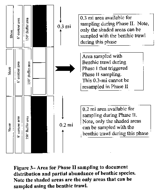
Table 1--Fish Collection Data Sheet Date: _________________ Begin Time: _________________ End Time: __________
Location Description: __________
__________GPS Coordinates (start/stop): ___________________________/__________
Depth (start / mid / end): __________
Flow conditions: __________
Secchi: _________________ Water Temp __________
Transect #: _________________ Buffer Dredge Zone Trawling
Collectors: __________
Location of vouchers: __________
Comments: __________
__________
Common Name # Collected # Returned # Preserved or Photographed
Table 2--Benthic lithophilic fishes that, if collected during Phase I sampling,
could trigger Phase II sampling.
Category 1 species Outcome if fishes are collected and/or defined as a Hit Sturgeon sp. Gravel Chub Mountain Madtom If Phase I Hit of One Species, Tadpole Madtom Then No dredging shall occur. Northern Madtom Brindled Madtom Eastern Sand Darter Longnose Sucker Iowa Darter Category 2 species N. Brook Lamprey Mountain Brook Lamprey If Phase I Trawling Hit of One Species or More, then Phase II Spotted Darter sampling shall be required. Spotted Sucker Category 3 species Silver Chub River Shiner If Phase I Trawling Hit of 3 or More Species, then Phase II Bluebreast Darter sampling will be required. Tippecanoe Darter Gilt Darter E02-919-A8. Tri-State River Products, Inc., Box 218, 334 Insurance Street, Beaver, PA 15009, in East Franklin and Rayburn Townships, Armstrong County, United States Army Corps of Engineers, Pittsburgh District. To amend Permit E02-919, which authorizes commercial sand and gravel dredging in select areas of the Allegheny River (WWF) and Ohio River (WWF), subject to review of fish surveys, mussel surveys and prescribed setbacks in Allegheny, Armstrong, Beaver and Westmoreland Counties to include Ohio River Mile Points 49.1 to 49.3 (Downstream beginning point: Kittanning, PA Quadrangle N: 20.5 inches; W: 0.1 inch, Latitude: 40° 51` 21.67"; Longitude: 79° 30` 1.41". Upstream end point: Mosgrove, PA Quadrangle N: 19.4 inches; W: 16.7 inches, Latitude: 40° 51` 26.11"; Longitude: 79° 29` 45.15"), left and right descending banks in East Franklin and Rayburn Townships, Armstrong County.
Permit No. E02-919
Attachment No. 3
Approved Dredging Areas by River Mile
County River Pool River Miles Municipalities Comments/
RestrictionsMussel Survey Expiration Date Armstrong Allegheny 5 30.7 to 31.25
L & RSouth Buffalo Township
Gilpen Township
05/19/13 31.65 to 31.7
L & RSouth Buffalo Township
Gilpen Township05/19/13 7 49.1 to 49.3
L & REast Franklin Township
Rayburn Township08/12/13 8 54.7 to 55.0
L & RPine Township
Washington Township05/31/12 55.0 to 55.2
L & RPine Township
Washington Township10/08/11 NOTES: ''R'' refers to Right Descending Bank and ''L'' refers to Left Descending Bank. E02-1326-A7 Glacial Sand and Gravel Company, P. O. Box 1022, Kittanning, PA 16201, in the City of Aliquippa, Baden Borough and Hopewell Township, Beaver County, United States Army Corps of Engineers, Pittsburgh District. To amend Permit E02-1326, which authorizes commercial sand and gravel dredging in select areas of the Allegheny River (WWF) and Ohio River (WWF), subject to review of fish surveys, mussel surveys and prescribed setbacks in Allegheny, Armstrong, Beaver and Westmoreland Counties to include Ohio River Mile Points 19.2 to 20.2 (Upstream beginning point: Baden, PA Quadrangle N: 0.4 inch; W: 15.0 inches, Latitude: 40° 37` 37.1"; Longitude: 80° 13` 59.8". Downstream end point: Baden, PA Quadrangle N: 2.9 inches; W: 15.3 inches, Latitude: 40° 38` 28.7"; Longitude: 80° 14` 9.12"), left descending bank in The City of Aliquippa, Baden Borough and Hopewell Township, Beaver County. Additionally, the Commonwealth of Pennsylvania Fish Community Sampling Protocol has been revised
Permit No. E02-584
Attachment No. 2
Approved Dredging Areas by River Mile
County River Pool River Miles Municipalities Comments/
RestrictionsMussel Survey Expiration Date Beaver Ohio Montgomery 19.2 to 20.2 L City of Aliquippa
Baden Borough
Hopewell Township10/01/13 19.2 to 20.2 R Baden Borough 04/12/11 20.6 to 21.6 R Conway Borough
Economy Borough03/21/10 21.0 to 21.1 L Hopewell Township Minimum 250 ft.
Setback from NP shoreline.05/16/09 21.1 to 21.3 L Hopewell Township 05/16/09 21.3 to 21.4 L Hopewell Township
Center TownshipMinimum 250 ft.
setback from NP shoreline.05/16/09 21.4 to 21.6 L Center Township Minimum 200 ft.
setback from NP shoreline.05/16/09 21.6 to 21.7 L Center Township 05/16/09 26.2 to 27.2
L & RBeaver Borough
Center Township
Potter Township
Vanport Borough04/12/11 31.0 to 31.4 R Industry Borough 07/26/10 Ohio New Cumberland 35.5 to 36.0
L & RGreene Township
Midland Borough
Shippingport Borough
03/21/10 NOTES: ''R'' refers to Right Descending Bank and ''L'' refers to Left Descending Bank. ''NP''--refers to normal pool.
APPENDIX B
Commonwealth of Pennsylvania Fish Community Sampling Protocol
June 29, 2006 (Revised March 2009)The (Department) Department of Environmental Protection shall require Pre Dredging Fish Sampling for the 2006 permit cycle. This sampling, protocol and criteria shall be used to satisfy the requirements of the Pennsylvania National Diversity Index process (''PNDI'') search, survey and conflict resolution. The sampling study parameters, protocol and criteria are as follows:
PRE DREDGING The industry shall conduct benthic trawling sampling of fish in areas proposed for dredging according to this Department protocol. Four (2 minute) unsnagged benthic trawls per segment (including buffer segments) are required. All sampling detailed as follows must occur between May 1 and October 1. Outside of that 5-month sampling window, surveys must be conducted with a temperature criterion of greater than or equal to 10° C (50° F) which has been achieved for a minimum of 5 consecutive days prior to the survey and must be maintained during the survey. The temperature can be monitored at the following USGS website:
* For the Allegheny River: http://waterdata.usgs.gov/nwis/uv?cb_00010=on&cb_00400=on&cb_00095=on&cb_ 00300=on&format=gif_default&period=7&site_no=030 49640.
* For the Ohio River: http://waterdata.usgs.gov/nwis/uv?03085734
Presently there exists only one temperature gauge on the Allegheny River and one on the Ohio River in PA. If in the future, additional gauges are added to the rivers then the closest gauge to the sampling site should be used for monitoring temperatures.
Notice must be provided to the Department a minimum of 7 days prior to initiation of a fish survey.
Sampling Methods and Procedures
Gear Type
Benthic Trawl
The trawl to be utilized is an extremely effective gear for sampling benthic lithophils (Herzog et al. 2005). The effectiveness of the benthic trawl shall vary based on the bottom substrate, river bed obstructions, boat speed (this shall determine the opening size of the net) and reaction of the fish. In the event that the trawl becomes snagged or turns over, this shall constitute a failed sampling event. The operators must retrieve the trawl, discard the contents of the failed trawl and reset the trawl for a new sampling event.
The Missouri-type 8 ft. wide trawl design described by Herzog et al. (2005) shall be the standard trawl employed during these surveys. The trawl's cod end is manufactured of 2.14 meters (7.02 ft) long 1.5 mm (1/17 in) diameter nylon twine with 19.05 mm (3/4 in) bar mesh and is lined with 3.18 mm (1/8 in) ace-style mesh. The body is manufactured with No. 7 (1-3/8 in. sq. mesh) netting and the bag is manufactured with No. 12 (1-1/4 in. sq. mesh) netting. The two trawl boards are 40.64 cm (16 in.) by 34.13 cm (9.5 in.) and equipped with 1.59 cm (5/8 in.) diameter twisted nylon tow lines 30.48 m (100 ft) in length. The footrope is 1.59 cm in diameter and 5.48 m (17.9 ft) long. The trawl chain is 44 mm (1 3/4") L by 25.4 mm (1") H by 6.4 mm (1/4") diameter. Ideally, the trawl shall be fished from a Jon boat 5.49-6.4 m (18-21 ft in length). The trawl shall be attached to two hard points on the boat with 9.5 mm (3/8 in) braided nylon rope. To effectively fish the trawl, ropes of various lengths should be used, depending on water depth. In water depths of 5 m (16.4 ft) or less, 15.24 m (50 ft) towlines should be used and at water depths between 5 m (16.4 ft) and 10 m (32.8 ft) towlines 30.48 m (100 feet) in length should be used. The length of rope utilized should be recorded on the data sheets provided in addition to river depth at the time of sampling. A small float should be attached to the end of the codpiece with a braided nylon rope. The rope should be longer than the maximum depth to be sampled. In the event the trawl has to be disconnected from the boat, the float shall mark the location of the trawl, facilitating recovery. The trawl shall be towed for 2-minutes unsnagged moving backwards downstream just faster than the current.
General Sampling Design
Using a depth finder or other appropriate gear type, the 6-foot depth contour shall be located at a minimum of three contiguous points along the proposed standard 0.1-mi linear sampling zone. Perpendicular to these points, the 150-foot no dredge area (buffer) shall be determined using an appropriate method (e.g., laser range finder). This distance shall be marked with additional buoys to demark the edge of the buffer zone and the beginning of the dredge zone. The location of each sampling event shall be indexed by river mile and marked with a global positioning system device.
Any permit request shall include a one-segment upriver and a one segment downriver station which must also be sampled. For example, if (5)-0.1 mile segments are requested then (7)-0.1 mile segments need to be sampled. All benthic trawling events must be completed within the time window between 2 hours after sunrise and 2 hours before sunset. Benthic trawl sampling shall occur within each 0.1 mi. reach as follows: three benthic trawls shall be performed within the proposed dredge zone and one benthic trawl shall be performed within the 45.72 m (150 ft) buffer. In addition, one benthic trawl shall be performed 0.1-mi upriver and 0.1-mi downriver from the proposed dredge zone (Figure 2). These 2 additional up- and downriver trawls shall be performed within the buffer area (2 trawls total) and in the adjacent up- and downriver dredge zones (6 trawls total). Therefore, a minimum total of 12 trawls shall be required to cover the 0.3-river mile sampling area. Data shall be recorded and reported for each individual trawl sample.
Criteria
If the benthic lithophils identified in Table 2 are collected during the surveys several outcomes are possible. If any Category 1 fishes are collected during benthic trawling sampling events, the permit area shall be restricted from dredging and a 0.3-mile upriver and 0.1-mile downriver no-dredge buffer shall be established; If any Category 2 species are collected during Phase I benthic trawling, then Phase 2 sampling shall be completed within 30 days (see Phase II sampling protocol). If three or more Category 3 species are collected during Phase I benthic trawling, then Phase II sampling shall be completed within 30 days (see Phase II sampling protocol). If no Category 1, 2 or 3 species are collected during Phase 1 trawl sampling events dredging for that river segment shall be authorized.
Phase II
If fish species listed in Category 2 (Table 2) are collected during Phase I sampling, then additional sampling under Phase II shall be required. Phase II sampling shall consist of benthic trawl sampling only, 0.30-mi upriver and 0.20-mi downriver from the proposed dredged area (Figure 3). If permittees do not seek authorization to dredge on the opposite side of the river then that area may be sampled with benthic trawling in Phase II. The additional sampling shall occur in 0.1-mi increments and shall consist of a maximum of three trawls for each 0.1-mi increment. Data shall be recorded and reported for each individual trawl sample. Hence, the standard sampling unit is three benthic trawls for Phases I and II sampling. During Phase II sampling, a minimum of five trawls is required. If any Category 2 fishes are collected, the same species of Category 2 fish shall be documented within a 0.5-mi reach and they shall be in at least 50% of their abundance (rounded to the nearest whole fish) from Phase I sampling.
If three or more Category 3 (Table 2) fish species are collected during Phase I sampling, then additional sampling under Phase II shall be required. Phase II sampling shall consist of benthic trawl sampling only, 0.30-mi upriver and 0.20-mi downriver from the proposed dredged area (Figure 3). If permittees do not seek authorization to dredge on the opposite side of the river then that area may be sampled with benthic trawling in Phase II. The additional sampling shall occur in 0.1-mi increments and shall consist of a maximum of three trawls for each 0.1-mi increment. Data shall be recorded and reported for each individual trawl sample. Hence, the standard sampling unit is three benthic trawls for Phases I and II sampling. During Phase II sampling, a minimum of five trawls is required. Phase II sampling must document an equal or greater number of Category 3 species per sampling and at least 50% of the most abundant species collected during Phase I sampling must be found in the .5-mile Phase II area to permit dredging to occur in the proposed area. If additional sampling does not demonstrate that these benthic fishes occur in equivalent abundance or in nearby habitats, then dredging shall not be permitted in the proposed area.
Category 2 and 3 fish species are a resource that requires protection due to their rarity; however, the dredging industry applicant may complete a Phase II assessment of the proposed project area to document that impacts to these fishes shall not be significant. If the applicant provides this Phase II information to document the widespread distribution of these Category 2 and 3 fish species then dredging shall be approved in the designated area. If additional sampling does not demonstrate that these benthic fishes occur in equivalent abundance or in nearby habitats, then dredging shall not be permitted in the proposed area.
Fishes captured during each sampling event shall be retrieved, identified to enumerated species and returned (if not held for further analysis). Species composition (see attached data sheet as Table 1) shall be recorded for each transect with each gear type used. The consultant shall retain appropriate voucher and questionable species (stored in 10% formalin). At least one specimen of each fish species shall be photographed, documented and returned. Voucher specimens for T&E species shall be provided to the PFBC at the following address: Chief, Natural Diversity Section, Division of Environmental Services, 450 Robinson Lane, Bellefonte, PA 16823.
Fishes that do not survive a sampling procedure and that are not retained as vouchers shall be buried on shore or returned to deep water for nutrient recycling by puncturing the swim bladder. Fish community sampling protocols shall be conducted by qualified fisheries scientists. All surveyors shall obtain a valid PFBC scientific collectors permit and a special Chapter 75 permit for the collection of threatened and endangered fish species. The contact for these permits is Chris Urban at the PFBC (814) 359-5113.
References
Dryer, M. 1996. Protocol on collecting, tagging, holding, transporting and data recording for researchers and managers handling pallid sturgeon. United States Fish and Wildlife Service. Bismarck, ND.
Emery, E. B., Thomas P. Simon, Frank H. McCormick, Paul L. Angermeier, Jeffrey E. Deshon, Chris O. Yoder, Randall E. Sanders, Shalliam D. Pearson, Gary D. Hickman, Robin J. Reash and Jeffrey A. Thomas. 2003: Development of a Multimetric Index for Assessing the Biological Condition of the Ohio River. Transactions of the American Fisheries Society 132(4):791--808.
Grisak, G. G. 1994. Procedure for using a trawl to sample deep-water zones of the Missouri River in Montana. Unpublished Report. Montana Department Fish, Wildlife and Parks. (http://infolink.cr.usgs.gov/Science/BenthicFish/index.htm)
Herzog, D. P., V. A., Barko, J. S., Scheibe, R. A. Hrabik and D. E. Ostendorf. 2005. Efficacy of a benthic trawl for sampling small-bodied fishes in large river systems. North America Journal of Fisheries Management 25:594--603.
Murphy, B. R. and D. W. Shallis, eds. 1996. Fisheries Techniques, 2nd ed. American Fisheries Society Publication, Bethesda, MD.
Nielsen, L.A. and D.L. Johnson. 1983. Fisheries Techniques. American Fisheries Society Publication, Bethesda, MD.
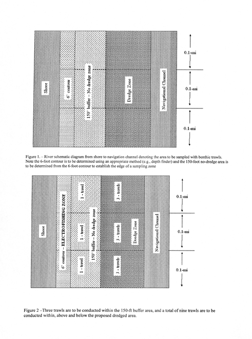

Table 1--Fish Collection Data Sheet Date: _________________ Begin Time: _________________ End Time: __________
Location Description: __________
__________GPS Coordinates (start/stop): ___________________________/__________
Depth (start / mid / end): __________
Flow conditions: __________
Secchi: _________________ Water Temp __________
Transect #: _________________ Buffer Dredge Zone Trawling
Collectors: __________
Location of vouchers: __________
Comments: __________
__________
Common Name # Collected # Returned # Preserved or Photographed
Table 2--Benthic lithophilic fishes that, if collected during Phase I sampling,
could trigger Phase II sampling.
Category 1 species Outcome if fishes are collected and/or defined as a Hit Sturgeon sp. Gravel Chub Mountain Madtom If Phase I Hit of One Species, Tadpole Madtom Then No dredging shall occur. Northern Madtom Brindled Madtom Eastern Sand Darter Longnose Sucker Iowa Darter Category 2 species N. Brook Lamprey Mountain Brook Lamprey If Phase I Trawling Hit of One Species or More, then Phase II Spotted Darter sampling shall be required. Spotted Sucker Category 3 species Silver Chub River Shiner If Phase I Trawling Hit of 3 or More Species, then Phase II Bluebreast Darter sampling will be required. Tippecanoe Darter Gilt Darter E02-1326-A8, Glacial Sand and Gravel Company, P. O. Box 1022, Kittanning, PA 16201, in East Franklin and Rayburn Townships, Armstrong County, United States Army Corps of Engineers, Pittsburgh District. To amend Permit E02-1326, which authorizes commercial sand and gravel dredging in select areas of the Allegheny River (WWF) and Ohio River (WWF), subject to review of fish surveys, mussel surveys and prescribed setbacks in Allegheny, Armstrong, Beaver and Westmoreland Counties to include Ohio River Mile Points 49.1 to 49.3 (Downstream beginning point: Kittanning, PA Quadrangle N: 20.5 inches; W: 0.1 inch, Latitude: 40° 51` 21.67"; Longitude: 79° 30` 1.41". Upstream end point: Mosgrove, PA Quadrangle N: 19.4 inches; W: 16.7 inches, Latitude: 40° 51` 26.11"; Longitude: 79° 29` 45.15"), left and right descending banks in East Franklin and Rayburn Townships, Armstrong County.
Permit No. E02-1326
Attachment No. 3
Approved Dredging Areas by River Mile
County River Pool River Miles Municipalities Comments/
RestrictionsMussel Survey Expiration Date Armstrong Allegheny 5 30.7 to 31.25
L & RSouth Buffalo Township
Gilpen Township05/19/13 31.65 to 31.7
L & RSouth Buffalo Township
Gilpen Township05/19/13 7 49.1 to 49.3
L & REast Franklin Township
Rayburn Township08/12/13 8 54.7 to 55.0
L & RPine Township
Washington Township05/31/12 55.0 to 55.2
L & RPine Township
Washington Township10/08/11 NOTES: ''R'' refers to Right Descending Bank and ''L'' refers to Left Descending Bank. E02-1600. Duquesne Light Company, 2645 New Beaver Avenue, Pittsburgh, PA 15233. To place and maintain fill on the bank of the Ohio River in the City of Pittsburgh, Allegheny County, United States Army Corps of Engineers, Pittsburgh District (Pittsburgh West, PA Quadrangle N: 16.4 inches; W: 6.5 inches, Latitude: 40° 27` 54"; Longitude: 80° 02` 50"). To place and maintain fill on the right bank of the Ohio River backchannel (WWF) for the purpose of upgrading the existing Brunot Island substation. The project is located on Brunot's Island near river mile 2.5, approximately 8,600.0 feet downstream from the West End Bridge.
EROSION AND SEDIMENT CONTROL The following Erosion and Sediment Control Permits have been issued.
Any person aggrieved by these actions may appeal, under section 4 of the Environmental Hearing Board Act (35 P. S. § 7514) and 2 Pa.C.S. Chapter 5, Subchapter A (relating to practice and procedure of Commonwealth agencies), to the Environmental Hearing Board, Second Floor, Rachel Carson State Office Building, 400 Market Street, P. O. Box 8457, Harrisburg, PA 17105-8457, (717) 787-3483. TDD users should contact the Environmental Hearing Board (Board) through the Pennsylvania AT&T Relay Service, (800) 654-5984. Appeals must be filed with the Board within 30 days of publication of this notice in the Pennsylvania Bulletin, unless the appropriate statute provides a different time period. Copies of the appeal form and the Board's rules of practice and procedure may be obtained from the Board. The appeal form and the Board's rules of practice and procedure are also available in braille or on audiotape from the Secretary to the Board at (717) 787-3483. This paragraph does not, in and of itself, create any right of appeal beyond that permitted by applicable statutes and decisional law.
If individuals want to challenge this action, their appeal must reach the Board within 30 days. Individuals do not need a lawyer to file an appeal with the Board. Important legal rights are at stake, however, so individuals should show this notice to a lawyer at once. If individuals cannot afford a lawyer, individuals may qualify for free pro bono representation. Call the Secretary to the Board (717) 787-3483 for more information.
Northcentral Region: Water Management Program Manager, 208 West Third Street, Williamsport, PA 17701.
ESCGP-1 4109802 Chief Gathering, LLC
Ted Wurfel
700 Fiarfield Road
Montoursville, PA 17754Lycoming Mifflin and Watson Townships North Fork Tombs Run
HQ
Tombs Run
HQ
Mud Run
EV
SPECIAL NOTICES
Notice of Planning Grant Awards under Section 901 of the Municipal Waste Planning Recycling and
Waste Reduction Act of 1988, Act 101The Department of Environmental Protection (Department) hereby announces the following grants to counties under the Pennsylvania Municipal Waste Planning, Recycling and Waste Reduction Act of 1988 (P. L. 556, Act 101) Section 901 and Section 208 of the Waste Tire Recycling Act/Small Business and Household Pollution Prevention Act (Act 190 of 1996).
Planning grants are awarded to counties for 80% of approved costs for preparing municipal waste management plans as required by Act 101, for carrying out related studies, surveys, investigations, inquiries, research and analysis, including those related to siting, environmental mediation, education programs on pollution prevention and household hazardous waste and providing technical assistance to small businesses for pollution prevention. Grants may be awarded for feasibility studies and project development for municipal waste processing or disposal facilities, except for facilities for the combustion of municipal waste that are not proposed to be operated for the recovery of energy. All grant awards are predicated on the receipt of recycling fees required by sections 701 and 702 of Act 101 and the availability of moneys in the Recycling Fund.
Inquiries regarding the grant offerings should be directed to Sally Lohman, Chief, Waste Planning Section, Department of Environmental Protection, Bureau of Waste Management, Division of Waste Minimization and Planning, P. O. Box 8472, Harrisburg, PA 17105-8472.
JOHN HANGER,
Acting Secretary
Act 101, Section 901 Planning Grant
Region County Applicant Project Description Grant Award Southeast Chester Chester County Plan Revision $156,000 Northeast Southcentral Northcentral Southwest Northwest
DRINKING WATER STATE REVOLVING FUND SPECIAL NOTICE
Special Notice under the Federal Safe Drinking Water Act (SDWA); 42 U.S.C. 300f, et. seq.
Southwest Region: Water Standards and Facility Regulation Program Manager, 400 Waterfront Drive, Pittsburgh, PA 15222-4745.
Project Location:
Applicant Applicant Address County Authority of the Borough of Charleroi 3 McKean Avenue
P. O. Box 211
Charleroi, PA 15022Washington Project Description: The Pennsylvania Infrastructure Investment Authority, which administers the Commonwealth's State Revolving Fund, is intended to be the funding source for this project. The Authority of the Borough of Charleroi proposes the following improvements: a 500,000 gallon elevated finished water storage tank near the Charleroi Area School District complex on Fecsen Drive, a finished water pump station at the Twin Reservoirs on Oakland Avenue, a 12" transmission line from the pump station to a connection at Wesley Avenue and Rodgers Lane and an interconnection with the North Charleroi Service District. The Department of Environmental Protection's (Department) review of the project and the information received in the Environmental Report for the project has not identified any significant, adverse environmental impact resulting from this proposal. The Department hereby approves the Environmental Assessment.
Project Location:
Applicant Applicant Address County Baden Borough 149 State Street
Baden, PA 15005Beaver Project Description: The Pennsylvania Infrastructure Investment Authority, which administers the Commonwealth's State Revolving Fund, is intended to be the funding source for this project. Baden Borough proposes waterline replacement of old lines which will improve water service and reduce the frequency of main breaks. The Department of Environmental Protection's (Department) review of the project and the information received in the Environmental Report for the project has not identified any significant, adverse environmental impact resulting from this proposal. The Department hereby approves the Environmental Assessment.
Project Location:
Applicant Applicant Address
County Beaver Falls Municipal Authority 1425 8th Avenue
P. O. Box 400
Beaver Falls, PA 15010Beaver Project Description: The Pennsylvania Infrastructure Investment Authority, which administers the Commonwealth's State Revolving Fund, is intended to be the funding source for this project. The Beaver Falls Municipal Authority Eastvale project consists of the following components: 1. Construction of an on bank river intake structure with an integrated raw water pumping station; 2. Associated construction of a Raw Water Transmission pipeline and communication facilities to connect the existing WTP SCADA to new intake facility; 3. Improvements to the chemical pretreatment capabilities of the WTP system; and 4. Revisions to the existing WTP electrical arrangement to facilitate the demolition of the existing intake structure. The Department of Environmental Protection's (Department) review of the project and the information received in the Environmental Report for the project has not identified any significant, adverse environmental impact resulting from this proposal. The Department hereby approves the Environmental Assessment.
Project Location:
Applicant Applicant Address County Monaca Borough 928 Pennsylvania Avenue
Monaca, PA 15061Beaver Project Description: The Pennsylvania Infrastructure Investment Authority, which administers the Commonwealth's State Revolving Fund, is intended to be the funding source for this project. The Monaca Borough proposes construction of a 500,000 gallon elevated water storage tank and 11,000 linear feet of water line replacement. The Department of Environmental Protection's (Department) review of the project and the information received in the Environmental Report for the project has not identified any significant, adverse environmental impact resulting from this proposal. The Department hereby approves the Environmental Assessment.
Project Location:
Applicant Applicant Address County Southwestern Pennsylvania Water Authority P. O. Box 187
1442 Jefferson Road
Jefferson, PA 15344Greene Project Description: The Pennsylvania Infrastructure Investment Authority, which administers the Commonwealth's State Revolving Fund, is intended to be the funding source for this project. The Southwestern Pennsylvania Water Authority proposes the installation of approximately 6,700 linear feet of 12" water line, 8,900 linear feet of 8" water line, 1,700 linear feet of 6" water line, 250 service connections, a 500,000-gallon prestressed concrete water storage tank, associated fire hydrants, connections and restoration for the Village of Nemacolin. The Department of Environmental Protection's (Department) review of the project and the information receivedin the Environmental Report for the project has not identified any significant, adverse environmental impact resulting from this proposal. The Department hereby approves the Environmental Assessment.
Project Location:
Applicant Applicant Address County Jackson Township
Water Authority2949 William Penn Avenue
Johnstown, PA 15909Cambria Project Description: The Pennsylvania Infrastructure Investment Authority, which administers the Commonwealth's State Revolving Fund, is intended to be the funding source for this project. The Jackson Township Water Authority proposes pumping facilities upgrade, construction of a 278,000 gallon capacity water storage tank and 22,000 LF of 6" and/or 8" diameter water distribution main. The Department of Environmental Protection's (Department) review of the project and the information received in the Environmental Report for the project has not identified any significant, adverse environmental impact resulting from this proposal. The Department hereby approves the Environmental Assessment.
Project Location:
Applicant Applicant Address County Buffalo Township Municipal Authority 707 South Pike Road
Sarver, PA 16055-9201Armstrong Project Description: The Pennsylvania Infrastructure Investment Authority, which administers the Commonwealth's State Revolving Fund, is intended to be the funding source for this project. The Buffalo Township Municipal Authority proposes the construction of a new water treatment plant to replace the existing plant which was built in 1919 and replacement of approximately 18,000 l.f. of waterline. The Department of Environmental Protection's (Department) review of the project and the information received in the Environmental Report for the project has not identified any significant, adverse environmental impact resulting from this proposal. The Department hereby approves the Environmental Assessment.
Project Location:
Applicant Applicant Address County Pittsburgh Water and Sewer Authority 1200 Penn Avenue
2nd Floor
Pittsburgh, PA 15222-4204Allegheny Project Description: The Pennsylvania Infrastructure Investment Authority, which administers the Commonwealth's State Revolving Fund, is intended to be the funding source for this project. The Pittsburgh Water and Sewer Authority proposes the removal of the existing longitudinal sludge collectors and cross collections in Clarifier Nos. 1--3 and their replacement with new equipment; the replacement of existing Motor Control Centers No. 6 and 7 in the electrical room at the clarifier tanks; the rehabilitation of 10,000 lineal feet of pipe main that is over 150 years old--the Fox Chapel 60" riveted steel pipe water main from the Aspinwall Water Treatment Plant to the Borough of Blawnox; and the cleaning and rehabilitation of the Squirrel Hill above groundwater storage tank (3 million gallons capacity). The Department of Environmental Protection's (Department) review of the project and the information received in the Environmental Report for the project has not identified any significant, adverse environmental impact resulting from this proposal. The Department hereby approves the Environmental Assessment.
[Pa.B. Doc. No. 09-631. Filed for public inspection April 3, 2009, 9:00 a.m.]
No part of the information on this site may be reproduced for profit or sold for profit.This material has been drawn directly from the official Pennsylvania Bulletin full text database. Due to the limitations of HTML or differences in display capabilities of different browsers, this version may differ slightly from the official printed version.

